Analyze, Track and Act on Events in Real-Time
A Database for Insights into the Rapidly Changing World
Real-Time Intelligence
Kinetica's lockless architecture, distributed ingestion, and vectorized query enable you to work with numerous sources of streaming data as they pours in. Kinetica allows for simulataneous ingest and query, and avoids the need for constant re-indexing and re-aggregations as new data changes the picture.
Advanced Geospatial Capabilities
Kinetica is built to track billions of objects as they move in real-time. Over 130 geospatial functions, geo-joins, graph solving and matching makes analytics on spatial and time series data at scale easier and faster.
Lower TCO, Faster to Deploy
Kinetica's vectorized capabilities enable analysts and engineers to analyze and deploy systems quicker than ever. Vectorized algorithms allow for simpler data structures, which means less time engineering the data, more flexibility for exploring the data, and lower compute costs to meet FDCCI requirements.
How are Public Services Using Kinetica?
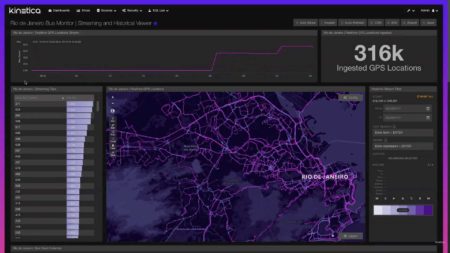
Smart Cities Advanced Monitoring
Track Entities in Real-time
Disaster Management
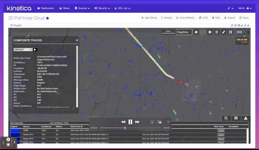
Modernizing Real-Time Geospatial Intelligence
State, local and federal governments require the ability to monitor global events to understand their potential impact on their citizens. As threats become more sophisticated, there is a growing imperative to deliver a dynamic common operating picture in real-time, against the full corpus of data, with the ability to detect new patterns across time and space
More Examples of Kinetica in Action
Build a Dynamic Common Operational Picture
State, local and federal governments require the ability to monitor changing events to understand the potential impact on their citizens. With Kinetica, governments can dynamically identify and mitigate threats to their communities and ensure the safety and well being of the citizens. In this demo, we show how Kinetica enables interactive visualization and analysis of GDELT data for enhanced intelligence, anomaly detection, and real-time response.
Cybersecurity Demo
Interactively analyze and visualize high-velocity networks and log data to uncover anomalies, suspicious behavior, and trends. Perform dynamic cyber threat analysis on streaming network traffic to identify malefactors on the fly. Apply location intelligence and graph analytics as well as machine learning to find needle in-the-haystack cyber threats and stop attacks before they can start using common operational picture software.
Watch Kinetica analyze 2 billion streaming network events in real time
Power Sustainability Initiatives
Leverage data and analytics to tackle complex environmental challenges. Perform real-time anomaly detection to improve energy efficiency, apply machine learning models to identify pollution, and collect and integrate billions of data points into smart applications for analysis and action. Kinetica partners with the U.S. Department of State, the Wilson Center, the Earth Day Network, the San Francisco Estuary Institute, and the World Economic Forum on environmental initiatives.

Infrastructure Planning
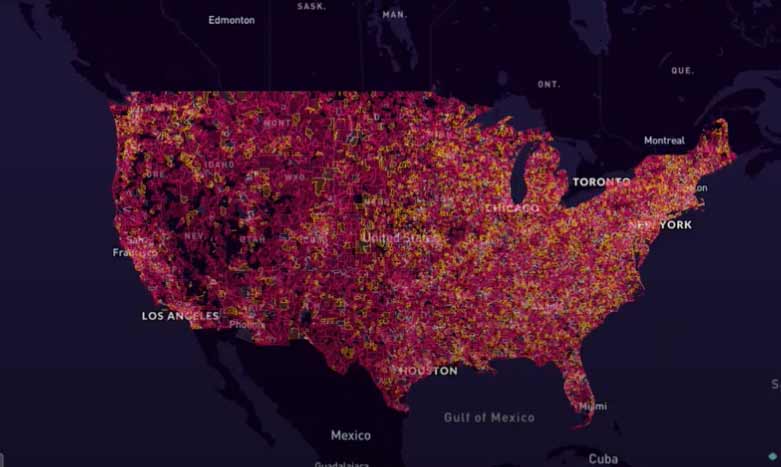
Accelerate 5G rollout in public sector environments with interactive network visualization at scale, line-of-sight analysis, and predictive modeling of small cell network coverage to optimize decision-making. Run real-time scenario analyses leveraging RF propagation models to predict the impact of adding or moving 5G cells, consider more deployment configurations, maximize potential, and minimize risk. Apply predictive analytics and machine learning to understand network impacts and weaknesses in a population-dense environment.
Making Sense of Sensor Data
As sensor data grows more complex, legacy data infrastructure struggles to keep pace. A new set of design patterns to unlock maximum value. Get this complimentary report from MIT Technology Review:
Book a Demo!
The best way to appreciate the possibilities that Kinetica brings to high-performance real-time analytics is to see it in action.
Contact us, and we'll give you a tour of Kinetica. We can also help you get started using it with your own data, your own schemas and your own queries.